- info@bestnepaltrek.com
- +977 - 9818852722

- Home
- Destination Nepal
- Nepal Trek
- Off The Beaten Trek | Off The Beaten Trek Path in Nepal
- Limi Valley Trek | Limi Valley Trekking Itinerary
Limi Valley Trek | Limi Valley Trekking Itinerary
- Altitude : 4949 m
- Transportation : Car/Bus/Plain
- Meals : Breakfast/Lunch/Dinner
- Best Season : Oct,Mar,Apr,May,Jun
- Trek Hour : 8
- Accommodation : Hotel and Tent
USD 2695 per person
Trip Highlights
- The Humla-Limi Valley Trek is located deep in the suffocating Indian subcontinent and the icy plains of the Tibetan plateau.
- It is mostly the habitat of the Khasa tribe and is located in the northwest corner of the hidden valley of Nepal.
- The longest river in Nepal, the Karnali, flows to the Nepalese border at Hilsa, where the valley starts from the west side.
- This area is famous for rare flora and fauna such as the groundhog, the wolf, wild yak, blue sheep, snow leopard, etc.
Humla Simikot Limi Valley Trek.
“The Limi Valley Trek is located in the far northwestern Himalayan region of Nepal. It offers stunning views of the surrounding mountains and passes through traditional villages and ancient monasteries. It is a challenging yet rewarding trek for experienced hikers.”
Limi Valley Trekking Itinerary goes to a hidden valley in the northwestern Humla Simikot of Nepal. It is suffocating deep Indian subcontinent and icy plains of the Tibetan plateau. Simikot Humla is the District Headquarters. The lower slopes of Humla are home to the Khasa People, and it gets a lot of snowfall, remaining remote and snowy all winter. Located in Nepal’s northwest corner, Limi Valley Trek is one of the isolated valleys. Extending from the Himalayan border near Hilsa to another Chang-la pass between Nepal and Tibet. This ancient Trans Himalaya Limi Valley trek is beautiful and scenic. The Gyuckarka at 5,000 m Saipal 7,031 m, Byas, Rishi, Api, Kanjirawa, Kanti and Gorakh Himalayan.
The Limi Valley Trek is famous for rare flora and fauna; such as the groundhog, the wolf, the wild yak, the blue sheep, the musk deer (Kyang), the hare, the Himalayan black beer and rarely the snow leopard. Tibetan cultivated indigenous people settled here and have their dialogue and Tibetan language. They were unique traditions and cultures, and large beautiful towns such as Haljee and Gombyak can be found in Limi Trek wild patches. Since 2002 AD, this valley has been open to hikers recently, and the first group of foreigners was Mike A Murphy; a geoscience group from the University of Houston USA. This group has been exploring this area for about a month and a half. To protect this fragile ecosystem of this hidden valley. Nepal’s government issues a limited number of special-rate permits.
Humla once belonged to the great Malla Empire and was administered from Sinja near Jumla. Until 1787 this empire extended to Purang (Taklakot) and the fabulous “lost” villages of Toling (Zanda) and Tsaparang, north of Nanda Devi and Kamet Himal, in a remote southwest of Tibet. The usual salt grain trade with Tibet is still in a continuous process on the Humla Hilsa border, as before. In most of Nepal, this trade has ceased due to the importation of Indian salt. That’s the reason that China has eliminated many border trading posts in remote areas.
Upon arrival at Tribhuvan international airport, you will be welcomed to this mountain country—Nepal! One of our representatives will then transfer you to the respective hotel in Kathmandu. You can refresh yourself in the hotel, and in the evening you will be briefed about the trek, provided with the necessary checklist to bring with you on the journey, and a hotel room with a bed and breakfast plan.
We need a special permit for the Limi Valley trek, so, therefore, this is the day for preparing the permit. After your breakfast, our city guide picks you up from the hotel with a private vehicle and takes you to the world heritage sites of Swayambhunath (Monkey Temple), Pashupatinath Temple, Bauddhanath Stupa, and if there is still time, then takes you to Kathmandu Durbar Square and back to the hotel with a Best and Breakfast plan.
After our brief excursion in Kathmandu, we take a 45-minute flight from Kathmandu to Nepalgunj, situated in west Nepal. Nepalgunj is a town near the border with Nepal and India. The city itself is a fascinating town in Terai, highlighting Nepal's rich population. We frequent the local market in Nepalgunj and neighbouring villages. Stay the night in Nepalgunj.
After an early breakfast, we take an exciting flight from Nepalgunj to Simikot (2,910 m) and then trek to Dharapuri (2,300 m). It will take approximately 5–6 hours to reach the best camping spots. From Simikot we have to ascend around 300 m and then descend 800 m to the valley base at Maghhgaun, continue to Dharapuri campsite for overnight tents.
Today is our second-day hike, so we walk towards the remote village of Kermi. The trail is quite easy along the way. We follow the right bank of the Karnali River to our destination. After reaching the campsite, you can visit natural hot springs. It’ll take about 45 minutes to walk from the campsite. Today is approximately a 6 hour walk, and overnight at a tented camp.
After breakfast, we are heading towards Yalbang Gompa. The trails are simple ascent and offer amazing views of Mount Saipal, which is 7000 m high and the highest mountain in this area. You then proceed to climb the Karnali River through the pine forest before going down from the Sali Pass (3,113 m) to the Chumsa Khola for lunch. It's a two-hour walk to the campsite close to Yalban School after lunch. You may visit the 50-year-old Namka Khyung Zong gompa. The Red Hat group includes a Rinpoche, which means a religious teacher held in high regard among Tibetan Buddhists. The nearby mountains of the upper Humla region provide excellent views from the campsite. Overnight tented camp.
You gradually climb the steep hills after breakfast. Continue descending to the bank of the river. Then the trail is a bit easier for a while. Again, the path gradually ascends, and then you’ll cross the suspension bridge. (2,500 m) passes over here to the south side of the Karnali River and steps up to Muchu Village after a few hours. In Muchu, there is a police check-post that they will control. We get the permit, then we head down to our destination. You can see the hill. Sakya Monastery in Tumkot. The campsite is just beneath the Tumkot monastery for overnight stay
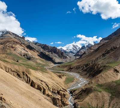
Today we leave the Karnali River to our right and begin climbing to La Nangla, a small path. The path drops out about an hour after the pass and you can see the man-made road to the Tibet border. Today for lunch, it will be at Pani Palbang, where you can find some local tea shops. After lunch, the path slowly goes up to Yari's spread out settlement. The campsite is around another hour from the Yari village to Thado Dhunga (4,000 m) for a tent overnight stay.
Today our destination is Nepal and Tibet's border town of Hilsa. It should take roughly 6-7 hours to travel. The road goes up and down every day and passes through the bushes of Juniper. You see, the Humli people's old route of trade. The trails go slowly across a 4,600 m pass of Nara La and fall into Hilsa on a gravel rocky road. Do not move together, but pay attention to moving afoot. A day out at Hilsa
You cross the bridge after the police check post at Hilsa and instantly continue a steep climb up the desolate slope for an hour to follow the main trail from Sher to the Limi Valley. The undulating path from here continues northeast towards a stone chorten (4,110 m), looking down towards the Humla Karnali valley. The sights are incredible, so you can see Lammergeier eagles in the forest, and blue sheep, so watch out for snow leopards. From here, the track is well developed, passing a rockfall and then ascending over a recent landslide. You follow the upper new path over the top of the collapse and drop down on the other side to reach the initial route. Lunch at Manepeme (4.014 m) is in a wide side gorge near a stream behind a hill. The Manepeme is named after a large stone carved with an "Om Mane Padme Hum", which is the wisdom of the Tibetan Buddhist Mantra. Overnight tented camp.
Today's destination will take Today, approximately 6 hours of travel. The distance seems short for the day, but it weaves its way through ravines and up and down hills on the extremely complicated route. The road is really challenging with many ups and downs. You are almost passing down the dreaded route of the trans-Himalayas, so always be watchful with yak and sheep bringing tons for trade. overnight tented camp.
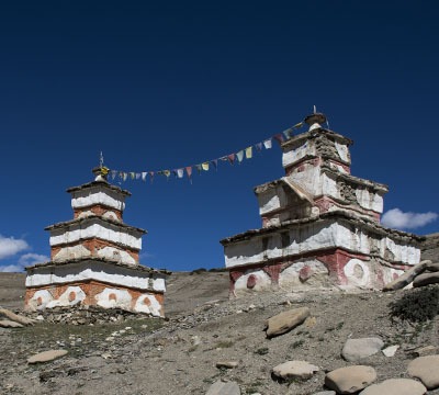
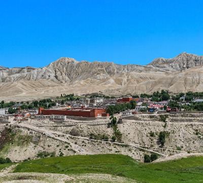
The groove continues to undulate and is getting rockier. A series of irrigated barley fields marks the start of a magnificent stone village at Jang village (3,930 m), with a white gompa. You're going to fly all the way through Halji. Halji village has an estimated population of about 500 people. The Halji people cultivate barley once a year and even trade with China—this village may be one of the world's most spectacular, surrounded by willow trees and large mountain ranges to the north. After exploring the Halji, we continued to Jang overnight.
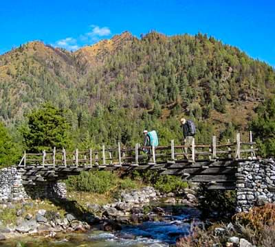
The path is, though, mostly flat and makes walking very enjoyable. To reach Talung, you cross a bridge south, through the sand dunes that make up Tshom Tso Lake. Along the way, you'll see a village that was abandoned a few years ago, but now the remains of a few houses are noticeable. When it is about an hour's climb to the Talung campsite across the river overnight.
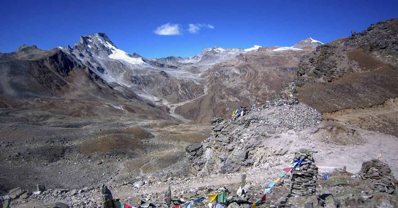
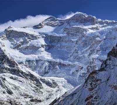
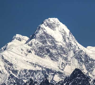
You'll reach the second pass on this day. The route ahead is exciting but also rugged and challenging. However, the climb at Nyalu La, at 4,940 m, to the highest point of this trip can give you stunning views of Humla Bandleader and the glaciers that extend to Tibet. You will walk down the steep path to Lake Selma (4630 m), overlooking Mount Kailash (6638 m) and Mt. Saipahl (7031 m). You'll navigate the river Sali down the road to today's Shinjungma Chhongsa Khola, a 3620 m. campsite. On the journey, you have plenty of stunning views of Mount Saipal. You'll rest at the campsite for the night after an exhausting 8 hours of hiking and a sluggish descent.
Your journey today takes you back to the village of Kermi, to civilisation. You'll descend for the first time on your walk of 3000 m across pine and birch forests. The hike is a fairly quick stroll on both sides of the trail along the stunning Salli Khola, with rocks towering. The trail soon crosses the Karnali River. The 7-hour walk to Kermi village is likely to fatigue you. And you'll calm your sore muscles in the Kermi village's 2670 m hot springs. You'll enjoy dinner at a tented camp and spend the night in it.
Today's hike to Simikot as the path at the start of the journey towards Darapuri 2,300 m, and it'll take around 7-8 hrs. You must finally begin a fun walk to Majgaon (2,290 m) and launch after that (2-hour uphill climb). You'll admire the breathtaking landscape vista of Nyinba Valley (4050 m) right after you cross a pass at more than 3,000 meters. You will continue to descend for 30 minutes to reach Simikot and celebrate your last dinner in the mountains and rest for the night.
Today we should take the earliest breakfast and try to get an early flight to Nepalgunj. After reaching Nepalgunj, we take an afternoon flight back to Kathmandu. After reaching the hotel, you can take a rest and freshen up. In the evening, join for a farewell dinner to mark the successful completion of the Rara Lake trek. hotel with bed and breakfast plans in Kathmandu.
You will be returning to your home filled with adventure memories during your stay in Nepal and the Limi Valley Trek in the western Humla Region's hidden valley. Our representative will help you with your departure from your homeland.
Cost Includes
- Airport transfer and drive in Nepal as per the above program.
- KTM, Nepalgunj, Humla, and Humla, Nepalgunj, KTM air tickets for guides and clients.
- Accommodation in standard hotels in Kathmandu and Nepalgunj with BB plan.
- team with all camping equipment like two-man tents, dining tents, kitchen tents, toilet tents, etc.
- daily fresh cooked meals (breakfast, lunch, and dinner) during the trip.
- Porters and horses are used during the trip to carry luggage and various types of equipment.
- Special Simikot Limi Valley permits entrance fees in the monasteries and all sightseeing as per the list.
- a local English-speaking experienced guide for during your trip.
- Medicine Kit and Office Expenses.
- all government taxes.
Cost Excludes
- Food for lunch and dinner in Kathmandu and Nepalgunj.
- Your international airfare and Nepal Visa fees
- Any alcoholic beverages, mineral water, soft drinks, snacks, etc.
- Your personal medical or evacuation expenses, including travel insurance, which includes rescue.
- All accommodation is subject to flight cancellation due to bad weather if there is a helicopter charter.
- Is there any extra cost for horse riding and natural disasters?
- Extra porters cost US$ 20 per person per day.
- Tips for the guide and porter
The Limi Valley Trek is a remote and off-the-beaten-path trekking route located in the far-western region of Nepal. It offers stunning natural beauty, unique cultural experiences, and a chance to explore the pristine Himalayan landscape. Here is some useful information about the Limi Valley Trek:
Trek Duration: The Limi Valley Trek is typically a long-duration trek that takes around 20 to 25 days to complete. It involves walking through rugged terrains, high mountain passes, and remote villages.
Permits: As the Limi Valley lies in a restricted area, you need to obtain special permits to trek in this region. You will need to obtain the "Restricted Area Permit" and then from the Department of Immigration in Kathmandu. Hiring a licensed trekking agency is usually required to obtain these permits.
Best Time to Trek: The best time to undertake the Limi Valley Trek is during the months of May to October. The weather during this period is generally stable, with clear skies and favourable temperatures. However, it's important to note that weather conditions in the high Himalayas can be unpredictable, so be prepared for sudden changes.
Difficulty Level: The Limi Valley Trek is considered a challenging trek and requires a good level of physical fitness and previous trekking experience. The route involves high-altitude passes, steep ascents and descents, and long hours of walking. Proper acclimatization and preparation are essential.
Accommodation and Facilities: Since the Limi Valley Trek is a remote and less-travelled route, accommodation and facilities along the trail are basic. You can expect to stay in simple teahouses or camp in designated camping areas. It's advisable to carry your own camping gear if you plan to camp. Additionally, pack enough food and water supplies as there may be limited availability in some areas.
Cultural Highlights: The Limi Valley is home to the indigenous Tibetan-speaking community of Limis, who have preserved their unique culture and traditions for centuries. During the trek, you'll have the opportunity to visit ancient monasteries, interact with the locals, and witness traditional ceremonies. Respect the local customs and traditions and be mindful of their religious beliefs.
Altitude Sickness: As the trek involves significant altitude gains, it's crucial to acclimatize properly to avoid altitude sickness. Take your time, ascend gradually, stay hydrated, and listen to your body. It's recommended to include rest days in your itinerary to allow for acclimatization.
Safety Considerations: Trekking in remote areas always carries some inherent risks. Ensure that you have travel insurance that covers trekking activities and emergency evacuations. Hire an experienced guide who is familiar with the region and can provide guidance and support throughout the trek.
Remember, the Limi Valley Trek is a challenging and remote adventure that requires careful planning and preparation. It's advisable to consult with a reputable trekking agency or local experts to obtain the most up-to-date information and guidance for your specific trek.
Certainly! Here are some frequently asked questions (FAQs) about the Limi Valley Trek:
Q: Where is the Limi Valley located?
A: The Limi Valley is situated in the northwestern part of Nepal, close to the border with Tibet (China). It lies in the remote and pristine region of Humla, which is known for its untouched natural beauty.
Q: How long is the Limi Valley Trek?
A: The duration of the Limi Valley Trek varies depending on the route and itinerary chosen. On average, it takes about 17 to 21 days to complete the trek.
Q: Is a permit required for the Limi Valley Trek?
A: Yes, a special permit is required to trek in the Limi Valley. You need to obtain a Restricted Area Permit from the Department of Immigration in Kathmandu. Additionally, you also need to acquire a TIMS (Trekkers' Information Management System) card.
Q: What is the best time to do the Limi Valley Trek?
A: The best time to undertake the Limi Valley Trek is during the spring (March to May) and autumn (September to November) seasons. These months offer stable weather conditions, clear skies, and favourable temperatures for trekking.
Q: Is the Limi Valley Trek challenging?
A: Yes, the Limi Valley Trek is considered to be a challenging trek. It involves traversing high mountain passes, including the Nara La Pass at an elevation of 4,620 meters (15,157 feet), and dealing with remote and rugged terrain. Previous trekking experience and a good level of fitness are recommended.
Q: What is the maximum altitude reached during the Limi Valley Trek?
A: The highest point of the Limi Valley Trek is the Nyalu La Pass, which stands at an altitude of approximately 5,085 meters (16,682 feet). This pass offers breathtaking views of the surrounding Himalayan peaks.
Q: Are there any accommodation facilities along the Limi Valley Trek?
A: The Limi Valley Trek is relatively remote, and accommodation options are limited. Tea houses and guesthouses are available in some villages along the route, providing basic amenities. However, it's advisable to carry a tent for camping as well, as it may be necessary in certain sections.
Q: What is the transportation mode to reach the starting point of the Limi Valley Trek?
A: The starting point of the Limi Valley Trek is usually Simikot, the administrative headquarters of the Humla district. To reach Simikot, you can take a domestic flight from Kathmandu to Simikot Airport. The flight duration is approximately 1 hour.
Q: Is it possible to do the Limi Valley Trek independently?
A: The Limi Valley Trek is considered a restricted area, and a guide is mandatory for trekking in this region. Hiring a licensed guide not only ensures your safety but also helps in navigating through the challenging terrain and understanding the local culture.
Q: What are some highlights of the Limi Valley Trek?
A: The Limi Valley Trek offers several highlights, including stunning landscapes, traditional villages, Buddhist monasteries, and encounters with the local people, who follow a unique Tibetan culture. You also get to witness the beauty of the remote Limi Valley and the breathtaking views of the surrounding Himalayan peaks.
These are some of the frequently asked questions about the Limi Valley Trek. Remember to consult with a reputable trekking agency or local experts for the most up-to-date and accurate information before embarking on your journey.
Related Packages
Nar Phu Teri-La Pass Trek | Terila Pass Trek Via Nar Phu Valley
20 Days - 19 Nights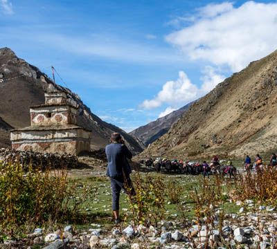

Kanchenjunga Base Camp Trek | Kanchenjunga South Base Camp
25 Days - 24 Nights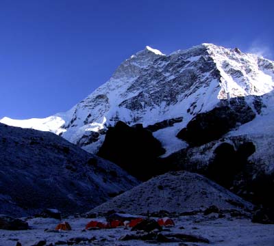
Ruby Valley Ganesh Himal Trek | Ruby Valley Trekking
18 Days - 17 Nights
Rolwaling Tashi Lapcha Pass Trek | Tso Rolpa Lake Trek
18 Days - 17 Nights