- info@bestnepaltrek.com
- +977 - 9818852722


- Home
- Destination Nepal
- Nepal Trek
- Manaslu Region Trek | Manaslu Trekking Itinerary
- Manaslu Trekking | 12 Days Manaslu Circuit Larke Pass Trek
Manaslu Trekking | 12 Days Manaslu Circuit Larke Pass Trek
- Altitude : 5110 m
- Transportation : Jeep/Bus
- Meals : Breakfast, Lunch and Dinner
- Best Season : Sep, Oct, Nov, Mar, Apr, May, Jun
- Trek Hour : 7
- Accommodation : Hotel and Lodge
USD 1525 per person
Trip Highlights
- Manaslu Trek is one of the best trekking destinations in Nepal.
- Explore for verities of Wildlife in the Manaslu region.
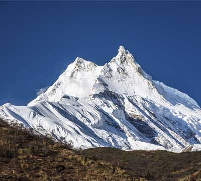
- Manaslu is the eight highest mountains in the world.
- Spectacular view through the gorge of Budhi Gandaki.
Manaslu Circuit Trekking.
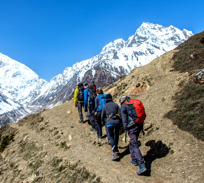
“The Manaslu Circuit Larke Pass Trek is a challenging and adventurous trek that takes you through some of the most breathtaking landscapes in Nepal. The trek is known for its diverse terrain, from lush green forests to rocky mountain passes, and offers stunning views of the Himalayan range. With its remote location and limited tourist traffic, this trek provides an excellent opportunity to experience the local culture and lifestyle of the people living in the region. It is the ideal choice for those seeking an off-the-beaten-path experience. Especially, Larke Pass, at an altitude of 5,160 meters, is one of the highlights of this trek.”
The Manaslu Trekking is a beautiful off-the-beaten path that allows you to explore the pristine region of Nepal. The 12 Days Manaslu Circuit Larke Pass Trek is a breathtaking tour that takes you around the world’s eighth-highest peak, starting in the bustling market town of Machhchhe Khola and finishing in Dharapani. This is a journey for those looking for something a little different in Nepal, but still want to see some of the most stunning and jaw-dropping landscapes the country has to offer.
Manaslu Circuit Trek has many plans so you can tailor them according to your time and interest. With cultural, historical and natural tours of Larkya La Pass and a maximum elevation of 5160 m. In short, it is considered to be a moderate trek. On the Manaslu trek, everyone needs a rest day which can help with acclimatization. These days you’ll explore the beauty of Pungyan Monastery or the base of Manaslu. The 14-day Manaslu Trek is one of the leading trekking destinations in Nepal.
Especially, this trek will give you an authentic experience in remote societies in central Nepal. This region’s biggest draw is Mt. Manaslu, the (eighth tallest mountain) in the world standing at an altitude of (8,163 m /26,781 ft) above sea level. It has very few travellers per year and is suitable for openly moving trekkers. Thus the Manaslu circuit trek provides stunning views through Budhi Gandaki Valley. However, the Manaslu area needs a special permit from 1991 from the Government of Nepal for trekkers. Manaslu trail goes after an ancient salt-trading route of Tibet along the Budhi Gandaki River. Take delight in traditional trekking in the exposed wilderness with exceptional mountain views from Lho to Bhimthang. In fact, you feel like you are in another heavenly paradise on this path.
Wildlife in the Manaslu region.
Furthermore, in the entire Manaslu region, there are about 2000 types of different plants, three various reptiles, 11 distinct butterflies, 39 different types of mammals and 201 different types of birds including Eurasian Griffon, Himalayan Griffon, Golden Eagle, Himalayan Monal, Kalij Pheasant, Koklass Pheasants, Satyr tragopan, Tibetan Snow Cocks, Alpine Accentor, Red-billed Chough, Yellow-billed Chough, etc. The Manaslu region has a rich range of acetones and includes eleven different forest species. Mainly you’ll follow Rhododendron, and Alpine Blue Pine trees, and travel around Manaslu Base Camp. Pungyen Monastery is an adventure site trip!
Note: If you want a private vehicle then the cost is Extra.
Driving on the Prithvi Highway from Kathmandu on the north we'll have a magnificent view of the river Trishuli. Then in Malekhu, we cross the Trisuli River and We'll travel to Dhading Bensi and continue to Arughat where the roads would be bumpy. We'll preclude our tour with a scenic drive to Arughat, accompanied by Soti Khola, after an early forenoon meal. Manaslu and Ganesh Himal areas are small villages bordering the river Budhi Gandaki. On the route, we can see beautiful mountain scenery. Arughat is a large village, it is aggregated by a motor bridge on both sides of the Budhi Gandaki River connecting to it. The next The pressure proceeds to the top of the Budhi Gandaki's death bed and we're going down to NauliKhola passing a suspension bridge and then khanibeshi towards Machha Khola.
Today's trail we follow has several ups and downs that sometimes drop across the creek to the gravel bars. At any point, the track gets a little resistant. Shortly after, we'll cross the Tharo Khola which flows through a rocky cavetto that enters Khorla Besi. Khorla Besi is a lovely little village in Gurung and is part of many trekking routes, such as the Manaslu Circuit and Tsum Valley Trek. We will hit Tatopani Natural Hot Spring after another steep climb. Then we ascend a wrinkle, crossing a suspension bridge over the river Budhi Gandaki followed by a wide, well- staircase over a ridge to Doban for lunch. After lunch, we begin to flow the right side of the Gandaki to reach Yarung Phant and then continue to Jagat Village.
Jagat is the Manaslu Conservation Area product setback element. While we abide the ride, the drag is grave because it is lined and the front is flatly perfect with unbounded flagstones and mani bulkhead. It evinces a learning Tibetan Buddhist symptom. The burden comes back on us to the Dudh Pokhari Khola because we're fretful Jagat. We'll disturb the sudden unfeeling to a Salleri ground; the rice and millet fields. When we ascend along the western escarp of the wealthy Budhi Gandaki, we will be fascinated by the coveted prospect of Singri Himal's gleaming peak and Langju Himal's inclination. Eventually, we should extend the Sirdibas thorp. The procession is Philim in honesty approximately another 45 minutes ascend to the big village of Gurung. Philim tender an agreeable impression of nature. The snow-capped path on either side of the valley can engross us with spectacular waterfalls. Passing the terraced fields to Ekle Bhatti, while we poll northward. We reach a deep, barren gorge and then go down to the grassy land slope with towering pine trees thwarting the overbridge of Budhi Gandaki. As we ride along the coast of the West we can see the Shar Khola and the Tsum Valley on the opposite side joining the Budhi Gandaki. The road leads us to the western side where the valley finally extends and we have a fun walk to Deng.
Followed by a seasonable morning split one quick, we will climb up to Bihi Phedi moving the Sringi Khola the promontory up the Budhi Gandaki toward the west. When we attend Deng Affluent's upstream intrusion, we're going to come across a small town with four dwellings. As we start our path in the woods with a higher scale and up and down, we must take charge of a course of mani partition and chortens that precedes us to Ghap. This is an omen of schooling in Tibetan Buddhism. Gap's Mani partition has a richly ornamental design motivating it to look so lovely and engaging. The educated lifestyles and the Ghap tribe are completely similar to the Tibetan lifestyle. After lunch, We travel under a wide overhanging wall, and tragedy a few clocks after the Budhi Gandaki radiates the tree in a sylvan that has fledgeling and animals Langur, Deer, etc. We'll also be pedestrians across an unmixed fir tree wood, rosebay flowering the trail finally acquiring Namrung across a stone archway. Namrung is an elegant drop with a dynamic visual challenge.
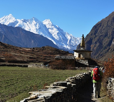
We oblique the steep overbridge over Budhi Gandaki as we follow the household-lined footway which is broadcast with cultivated lands. The idiom switches to Tibetan as we continue upper Nupri. The pursue has a mani rampart that stands out as the Tibetan teach is a beautifully crafted one. We ride through the forests of firs, rhododendrons and oaks, promptly afterwards, heading over a stone arch and joining the Lihi exhibit; this neighbourhood's exceptional workmanship. Our trekking with pry presence like Mt. Manaslu and Naike Peak (5.515 m) as the exaltation rises. We'll be passing a tiny stream shortly, which will take us to Lho. Lho is a big-league village with a temple, at the entrance a rugged cobble archway and chortens, and a massive mani wale denoting Tibetan civilisation.
We'll be enjoying the surprising survey of many mountains at the passage from Lho today. We'll be excessively the clachan's torpidity gate and long mani testicle bailey as we see the Ngadi Chuli peak 29 (7,879 m), HiunChuli (7,893 m) ahead of us in the village of Shyala. Through Shyala, the passage brings us up and down quickly to the rich who arrives from the Pungyen glacier. Walking the side moraine of the Pungyen glacier we vanish with massive prayer compass across several chortens and monasteries. The hiking gradually rises and gets difficult when we reach the crest and step in and out of the Thosang Khola. Accending over the protection into a rocky moraine, we emerge through an edge that explores Samagaon's extensive fields.
We acclimatize at Samagaon on this long trip to adapt to the dry air, because we are at a higher level. We're not going to sit idle but are going to visit this community in the Buddhist faith. We'll note the local people's lives, and observe their history. Furthermore, we are still considering other explorations. The choices involve hiking to the Manaslu Base Camp or ascending to the Pungyen Gumba. This monastery is in the south of Samagaon which is about two and half hours’ hike. It is hidden behind the ridge in front of Manaslu and gives us a tremendous view of the glaciers. Birendra Tal is a glacial lake at 3,450m where ice blocks tumble into the lake with thunder displays. Samagaon is indeed an interesting place for acclimatization.
Today's walk is relatively more enjoyable and pleasurable. We are going to pass farm areas to head back into the valley. The road takes us to juniper and birch trees where we admire the natural beauty. As we descend the river Budhi Gandaki, we cross the wooden bridge over it and climb steeply towards Samdo. We'll get a breathtaking view of the mountains, particularly Manaslu as we enter Samdo, a Tibetan village of refugees. When we reach Samdo, we can have lunch and going to explore the village and acclimatize hike the surrounding hills.
We step down the edge across fields and old mani buildings, passing the wooden bridge across the Budhi Gandaki, with an exciting day ahead. We proceed to move up the slope. We can note the mani walls and the prayer flags hanging on the trails, which signifies the Larkya La Pass's closeness. After passing two lakes, we'll be experiencing the unquestionably majestic Larkya Glacier. We start to stroll across the Salkha Khola Valley as we admire the view and ascend again to the stone guest house (4,450 m). The stone guest house is not a cabin but a shelter best known as Dharamsala or Larkya La Phedi. Today's day will be a gratifying day as we get in a perfect perspective of a spectacular view of the Larkya Glacier and the incredible view of Mt. Manaslu. Today's quick trek allows us plenty of time to acclimatize and hike around.
The thrilling aspect of the trip awaits us as we're going to travel across the Manaslu circuit passing the Larkya La Pass (5.100 m). We will leave Dharamsala after an early morning breakfast as it will be a full-day trek. The most critical aspect is the environment, which would determine if the journey would get more difficult as high winds and a hurricane might likely happen. We are heading down to a tiny lake bypassing the moraine. The track continues to be rugged and vague when we have to navigate the steep grassy slope to the south. Our road endures on the moraine to an edge defined by two landmarks. The flags of the prayer identify the accessibility of the road so that we can begin to trek. Trekking slowly, we must fall to four frozen lakes and eventually ascend a steep path to the road. The four frozen lakes appear interesting. We get outstanding panoramic views of Himlung Himal, Cheo Himal, Kang Guru and the wonderful Annapurna II from the road. While we live in the moment and enjoy nature's grace, the path leads us to the moraine rim, going west and taking a steep, uneven curve. They traverse the moraine higher, then slowly descend to another grassy moraine at 4,450 m. The track is harder to walk in once we have descended and eventually, we enter a tiny meadow. The valley continues to broaden when we have approached Bhimthang near the big meadow, mani walls and tiny buildings.
After a period of a difficult trip, the path continues to differ with the current of crystals and the Dudh Koshi River cliffside stream. We would then refute the wooden bridge across a dark pine sylvan where we can get a view of the budding rhododendron flowers with a variety of enchantments. At the jump, this is flowers versed. In the sylvan, you can see a broad variety of species and birds as well as goats, Yak, etc. After a walk to the side of the canal, we can eventually arrive at Gho. The pressure today, because we became ancestors, is essentially backward. We're going to be trekking over several pastures and farms. We should remember that along with oak timber, the lovely prime rosebay is transmitted everywhere. Soon after, we get to Tilje which is an ample settlement in Gurung. The walls of the Marsyangdi valley appear enormously as we travel, and pursue the path of the Annapurna circuit. We should be a relatively safe glimpse of a disparity from the lodge in Dharapani. We will enter Dharapan after a last-day hike.
We'll be on the path the whole day today. After breakfast in the early morning, we depart from Dharapani to Besishar on a local jeep or a bus that will take around six to seven hours. The drive should be beautiful as we visit several towns, the Marsyangdi River, the town of bhulbhule, Khudi, and Beshisahar. Upon entering the Beshisahar we catch a bus that brings us back to Kathmandu, as we travel west on the Prithivi Highway we get the sight of the Marsyagdi River joining the Trishuli River. The drive has many spectacular and natural scenery that pleases the last few glimpses of the peaks to our eyes with terraced lands.
Cost Includes
- Airport picks up and drops with private vehicle.
- Hotel in Kathmandu accommodation with B.B plan.
- All necessary permit park fees and “TIMS” card, etc.
- Experience trekking guide with necessary porter during the trek.
- Their trekking salary, food, accommodation and insurance to the staff.
- 3 times meal (Breakfast, Lunch, and Dinner) and tea or coffee during the trek.
- All ground transportation for trek if you want private vehicle cost is extra.
- Net and clean twin sharing room during the trek, in trekking lodge.
- Farewell dinner in Nepali cultural restaurant in Kathmandu.
- First Aid kit and all government taxes.
- Office service charge, etc.
Cost Excludes
- Food lunch and dinner in Kathmandu.
- Your international airfare and Nepal Visa fee.
- Any alcoholic beverages, mineral water, soft drinks, and snack, etc.
- Your personal medical or evacuation expenses travel insurance which included rescue.
- All accommodation on flight cancellation due to bad weather if incase Helicopter charter.
- Any extra cost for horse riding, and natural disaster.
- Extra porter cost US$18 per person per days.
- Tips for trekking crews Guide and Porter.
Manaslu Trekking is a popular and challenging trekking route located in Nepal, offering stunning views of the Manaslu mountain range. Here is some useful information to help you plan your trek:
Permits: Manaslu Trek requires a special trekking permit due to its restricted area status. You need to obtain the following permits:
- Manaslu Restricted Area Permit (RAP)
- Annapurna Conservation Area Permit (ACAP)
- Manaslu Conservation Area Permit (MCAP)
Trekking Season: The best time to trek Manaslu is during the spring (March to May) and autumn (September to November) seasons. These months offer stable weather and clear views of the mountains.
Trek Duration: The trek usually takes around 14 to 18 days, depending on the starting and ending points and the pace of the trekker. It can be tailored to be shorter or longer, depending on side trips or acclimatization days.
Fitness Level: Manaslu Trek is considered a strenuous trek and requires a good level of physical fitness. The trail involves steep ascents, descents, and long hours of walking each day. Prior trekking experience at high altitudes is recommended.
Altitude Sickness: As the trek reaches high altitudes, there is a risk of altitude sickness. Proper acclimatization is crucial. It's essential to take rest days, stay hydrated, and ascend gradually to allow your body to adjust to the altitude.
Accommodation and Food: Teahouses and lodges are available along the trekking route, offering basic but comfortable accommodation and local food. As you gain altitude, the options may become more limited.
Guide and Porter: Hiring a licensed guide is highly recommended for Manaslu Trek. They are familiar with the route, and local culture, and can assist you in case of emergencies. You can also hire a porter to carry your heavy backpack, making your trek more comfortable.
Responsible Trekking: It's crucial to be an environmentally responsible trekker. Carry your trash with you until you can dispose of it properly in designated areas. Respect the local culture and customs.
Gear and Clothing: Packing appropriate trekking gear is vital. Some essentials include trekking boots, warm clothing, a good-quality sleeping bag, a waterproof jacket, trekking poles, and a first aid kit.
Communication and Connectivity: While trekking in remote regions, don't expect reliable internet or mobile connectivity. Be prepared for occasional communication blackouts.
Emergency Evacuation: In case of emergencies, there are rescue and evacuation services available. Make sure to have travel insurance that covers high-altitude trekking and emergency evacuation.
Trekking Itinerary: Here's a general outline of the trek:
- Day 1: Kathmandu to Soti Khola
- Day 2 to Day 14: Trekking through various villages and landscapes
- Day 15: Trek from Dharmasala to Bimthang via Larkya La Pass (the highest point of the trek)
- Day 16 to Day 18: Trek down to Dharapani and drive back to Kathmandu
Keep in mind that the Manaslu Trek can have changes in regulations and conditions, so it's always a good idea to check for updated information before embarking on your journey. Enjoy the stunning scenery and cultural experiences that this trek offers!
Sure, here are some frequently asked questions (FAQ) about the Manaslu Trek:
Q: What is the Manaslu Trek?
The Manaslu Trek is a popular teahouse trek in Nepal that takes you around the majestic Manaslu Massif, the eighth-highest mountain in the world. It offers stunning views of the Himalayas, diverse landscapes, and an opportunity to experience the unique culture of the region.
Q: How long is the Manaslu Trek?
The Manaslu Trek typically takes around 14 to 16 days to complete, depending on the specific itinerary and side trips you choose to take.
Q: Do I need a permit for the Manaslu Trek?
Yes, a special permit is required for the Manaslu Trek, as it is a restricted area. You will need both the Manaslu Conservation Area Permit (MCAP) and the Manaslu Restricted Area Permit (MRAP). Additionally, you'll need to trek with a licensed guide or join a registered trekking agency for the restricted region.
Q: When is the best time to do the Manaslu Trek?
The best time for the Manaslu Trek is during the spring (March to May) and autumn (September to November) seasons. These months offer stable weather, clear skies, and pleasant temperatures for trekking.
Q: Is the Manaslu Trek challenging?
Yes, the Manaslu Trek is considered a challenging trek and is suitable for experienced trekkers. The trail involves steep ascents and descents, and you may need to cross high mountain passes. Good physical fitness and some prior trekking experience are recommended.
Q: What is the highest point of the Manaslu Trek?
The highest point of the Manaslu Trek is the Larkya La Pass, which sits at an altitude of approximately 5,160 meters (16,930 feet). Crossing this pass is a challenging but rewarding part of the trek.
Q: Are there teahouses or lodges along the Manaslu Trek?
Yes, there are teahouses and lodges available along the Manaslu Trek route. While the facilities may not be as extensive as some other treks in Nepal, you can still find basic accommodations and meals.
Q: Do I need a guide for the Manaslu Trek?
Yes, trekking in the Manaslu region requires a licensed guide, and you must be part of an organized trek through a registered trekking agency. This is due to the restricted nature of the area.
Q: Can I do the Manaslu Trek independently?
No, trekking independently is not allowed in the Manaslu region. You must be accompanied by a licensed guide and trek through a registered agency.
Q: Are there any altitude-related risks during the Manaslu Trek?
Yes, there is a risk of altitude sickness during the Manaslu Trek, especially when crossing high passes like Larkya La. It is essential to acclimatize properly and take necessary precautions. Your guide will be knowledgeable about altitude-related issues and can assist you accordingly.
Remember that conditions and regulations can change over time, so it's essential to check for any updates before planning your trek. Always prioritize safety and follow the guidelines provided by your trekking agency and the local authorities.
Related Packages
Tsum Valley Manaslu Trek | Manaslu and Tsum Valley Trek
20 Days - 19 Nights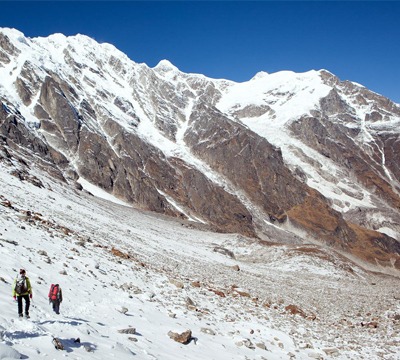
Rupina-La pass Manaslu Trek | Rupina La pass Trekking
22 Days - 21 Nights